Cesky Krumlov, a medieval city in the Czech Republic, recently hosted the annual conference of the International Map Trade Association (Europe) Conference and Trade Show 2006. Companies from more than 50 IMTA member countries had an opportunity to show their products and familiarize themselves with the atlases, maps, and guidebooks of their competitors, and to sign business contracts.
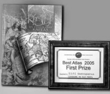
The prestigious jury named the publication Ancient Maps of Ukraine the best atlas of 2005, along with the wall map Ukraine: Hypsometric Map. Both prize-winning publications were developed and prepared for publication by the state research and production company Kartohrafiya (Kyiv), which was proclaimed the best specialty publishing house of Europe, Asia, and Africa of 2005.
“The album Ancient Maps of Ukraine is the second publication of the revived series Monuments of Ukraine’s Cartography,” says Olha Stetsenko, head of marketing. “It includes 90 facsimiles of ancient maps portraying Ukrainian lands from the late 15th to the mid-17th centuries, which were created by distinguished people of the day, including Claudius Ptolomy, Sebastian Munster, Jodocus Hondius, and Giovanni Antonio Maggi.
“These reproductions of originals stored in the archives of Lviv’s Vasyl Stefanyk Reference Library, which is under the aegis of the National Academy of Sciences, and in its counterpart, Ivan Franko National University of Lviv, correspond to contemporary Western European geographers’ ideas about our land, and obviously about its sociopolitical and cultural importance for the rest of the world, particularly Europe. Our hypsometric map of Ukraine, which is two by three meters, has a huge scale, 1:500,000. Generally speaking, the motto, ‘Maps Made by Professionals!’ can be printed on the front cover of any of our publications.”
Kartohrafiya is one of the leading specialized publishers whose books include atlases of highways and city plans in Ukrainian and Russian as well as Polish, English, French, and German; educational, tourist, and information atlases; office wall maps and globes. Our directors consider the Russian- and English-language Atlas of Snow and Ice Resources of the World, which was commissioned by UNESCO, the three-volume Atlas of the Ukrainian Language, the atlas Ukraine: Industry and Investment Activities; and the first Ukrainian-language coffee table book World Atlas, among their greatest achievements. Further proof of their success is Kartohrafiya’s numerous awards that have been conferred during international fairs, including the Grand Prix of last year’s publishers’ forum in Lviv for Ancient Maps of Ukraine (a real find for collectors and book lovers — Ed.), and the diploma awarded by the VII All-Ukrainian Rating “Book of the Year” for World Atlas.
The World Atlas is a Ukrainian version of the famous Harper Collins English atlas (the British are tops in cartography). “We regard our publication as a real achievement,” says Olena Vakulenko, the project’s executive editor. “Our previous atlas featured 20,000 place names; this one has 100,000, so you can imagine the amount of work that was done in two years
“Second, all the place names were translated from the original languages (with 40 translators working on it), and not from English as the intermediary language. This was done to avoid Ukrainization, as is the case with maps published in Russia, where the names of Ukrainian cities are transliterated the Russian way: Zaporozhye, Kiev, etc.
“Third, we made it possible for our readers to familiarize themselves with the world in their mother tongue. It should be noted that an independent compilation of this text (over 300 pages - Ed.) would take 10, maybe 15 years, precisely as long as it took the English editors (15 years).”
Kartohrafiya is now working on the National Atlas of Ukraine, to record the current status of our homeland, including climate, natural resources, political division, economy, and ecology. Stetsenko says that most countries have national atlases, and that having one is a matter of national prestige. The Ukrainian atlas is expected to appear in print in the first quarter of 2007. The first Atlas of Ukraine and Neighboring Territories, created by Volodymyr Kubijovyc, a geographer, and public and political figure, was published in 1937. Two years later this work was officially banned and all copies were destroyed. Miraculously, several survived.
Kartohrafiya publications are diversified, so much so that they can serve as souvenirs for Ukrainian delegations traveling abroad. They are also extremely useful for scholars, and as teaching aids for pupils and students. The fact that some of these publications are found in private book collections is proof of a collector’s good taste and wealth.


